METAR-TAF
Aeropuertos :
Lynchburg
Aberdeen
Abingdon
Ahoskie
Akron–Canton
Akron-Fulton
Albemarle
Allentown
Altoona
Annapolis
Asheboro
Asheville
Ashland
Athens
Baltimore
Baltimore
Baltimore Inner Harbor
Beaver Falls
Beckley
Bedford
Blacksburg
Blackstone
Bluefield
Boone
Bristol / Johnson / Kingsport
Buckhannon
Burlington
Butler
Cambridge
Camp Mackall
Camp Springs
Chapel Hill
Charleston
Charlotte
Charlottesville
Cherry Point
Chesapeake
Clarksburg
Clearfield
Clinton
Coatesville
College Park
Concord
Culpeper
Cumberland
Danville
Dover
Doylestown
Dublin
DuBois / Falls Creek
Easton
Edenton
Elizabeth City
Elkins
Emporia
Erwin
Farmville
Fayetteville
Fayetteville / Pope
Filadelfia
Filadelfia
Filadelfia / Blue Bell
Fort Belvoir
Fort Bragg
Fort Eustis
Fort George G. Meade
Fort Indiantown Gap
Franklin
Frederick
Fredericksburg
Front Royal
Gaithersburg
Galax / Hillsville
Gastonia
Georgetown
Goldsboro
Goldsboro / Seymour Johnson
Greensboro
Greenville
Greenville
Greer
Hagerstown
Harrisburg
Harrisburg / Middletown
Hatteras
Hazleton
Hickory
Hot Springs
Huntington
Indiana
Jacksonville-Albert J. Ellis
Johnstown
Kenansville
Kill Devil Hills
Kinston
Lancaster
Lancaster
Langley
Latrobe
Leesburg
Lewisburg
Lexington
Lincolnton
Louisa
Louisburg
Lynchburg
Manassas
Mansfield
Manteo
Marion / Wytheville
Martinsburg
Martinsville
Melfa
Millville
Monroe
Morganton
Morgantown
Mount Airy
Mount Holly
Mount Pocono
Newark
New Bern
New Castle
New Philadelphia
Newport News
Norfolk
Norfolk
Norfolk
North Wilkesboro
Ocean City
Orange
Oxford
Parkersburg
Patuxent River
Petersburg
Petersburg
Pickens
Pikeville
Pinehurst / Southern Pines
Pineville
Piney Island
Pittsburgh
Pittsburgh / West Mifflin
Pottstown
Quakertown
Quantico
Raleigh / Durham
Reading
Richmond
Richmond
Richmond / Ashland
Roanoke
Rock Hill
Rocky Mount
Roxboro
Rutherfordton
Salisbury
Salisbury
Sanford
Selinsgrove
Shelby
Siler City
Smithfield
South Hill
Spartanburg
Stafford
State College
Statesville
Staunton / Waynesboro / Harrisonburg
St. Inigoes
Suffolk
Tangier
Trenton
Virginia Beach
Wadesboro
Wakefield
Wallops Island
Warrenton
Washington
Washington
Washington
Washington
West Jefferson
Westminster
West Point
Wheeling
Wildwood
Williamsburg
Wilmington
Winchester
Winston Salem
Wise
Wooster
York
Zanesville
Virginia, Maryland, Delaware
América del Norte
Carolina del Norte
Carolina del Sur
Indiana
Kentucky
Norte del Atlántico
Nueva York
Ohio
Pensilvania
Tennessee
Lynchburg Regional Airport (Preston Glenn Field) Lynchburg, Virginia, Estados Unidos
latitud: 37-19-15N, longitud: 079-12-24W, altitud: 285 m
Observación El informe se hizo hace 7 minutos, a las 08:54 UTC
Viento 4 kt del sur-suroeste
Temperatura 8 °C
Humedad 61 %
Presión 1020 hPa
Visibilidad: 16.1 km
Cielo nuboso a una altura de 9000 ft
METAR: KLYH 260854Z AUTO 20004KT 10SM BKN090 08/01 A3011 RMK AO2 SLP193 T00830011 56007
Hora: 05:01 (09:01 UTC) Pronóstico El informe se hizo hace 3 horas y 41 minutos, a las 05:20 UTC
Pronóstico válido del 26 a las 06 UTC al 27 a las 06 UTC
Viento 6 kt del sur
Visibilidad: 10 km
Cielo despejado
A partir de las 26 a las 1500 UTC
Viento 7 kt del sur-suroeste
Visibilidad: 10 km
Escasas nubes a una altura de 10000 ft
A partir de las 27 a las 0300 UTC
Viento 11 kt del suroeste con ráfagas de 21 kt
Visibilidad: 10 km
Escasas nubes a una altura de 25000 ft
TAF: KLYH 260520Z 2606/2706 19006KT P6SM SKC FM261500 21007KT P6SM FEW100 FM270300 22011G21KT P6SM FEW250 WS020/24040KT
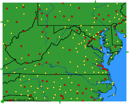
Observaciones y pronósticos meteorológicos de más de 4000 aeropuertos (mensajes METAR y TAF).
Los puntos amarillos y rojos representan las estaciones disponibles.
Ponga el ratón en el punto deseado para ver el nombre de la estación.
Haga clic para ver las observaciones y los pronósticos meteorológicos.
Para cambiar el mapa : haga clic en los botones verdes con una cruz de color negro para hacer un zoom, en el botón verde con un guión para alejar o en las flechas verdes para mapas adyacentes.